Michigan Prevention Data Atlaspowered by iRISE™

Free, open access — 83 counties
Use the Report Builder for one county on its own or for comparisons between counties. Check one county for a single-region analysis; check more to compare them side by side. The report renders immediately from the embedded dataset, then refreshes any indicator a live federal feed returns within twelve seconds. Every report leads with how it was completed, shows county comparison tables and charts, and marks each field that needs action from the organization, an individual, or the community.
Prepopulates the Solution Forge with these counties, weights, issue areas and problem statement.
Save as .pdf opens your browser’s print dialog; choose “Save as PDF” as the destination. Use the report below as it is, or carry these counties and weights into the Forge to generate solutions.
Your report will appear here. Print or save it as a PDF from the buttons above once generated.
Locate a problem in Michigan, map the intersections and the populations at their center, weight the eight domains on the iRISE™ 0–100 scale, and submit. The Forge returns solutions at the individual, organizational and structural levels, each described and cited to evidence-based sources, and closes with every citation that shaped it.
Suggested length: 500–700 words for the most depth — who is affected, by what, where, what has been tried, and what residents say. One or two sentences also generate helpful results. 0 words
Location: Michigan
Community co-design — part of Phase 1: how is the affected community at the table?
How to weight: every domain starts at 50, meaning it is present in this problem at an ordinary level. Move a slider up when that domain drives the problem — 75 for a major driver, 100 for the defining one. Move it down when it matters less — 25 for a minor factor, 0 to leave it out. Domains at 50 or above count toward the κ compounding factor. At 75 or above a structural solution is required. κ = 1 + 0.12 × (domains at 50 or above − 1). If you are unsure, leave it at 50.
Who carries this burden where systems overlap? Name the intersecting identity axes, then the experiences at the intersections.
Intersecting identity axes
Experiences at the Intersections
Save as .pdf opens your browser’s print dialog; choose “Save as PDF” as the destination.
Michigan’s 83 counties colored by burden level on the indicators you choose, from the same embedded dataset and live feeds the Report Builder uses. Hover for the county name and value; click up to three counties to compare them side by side and build a report from the selection.
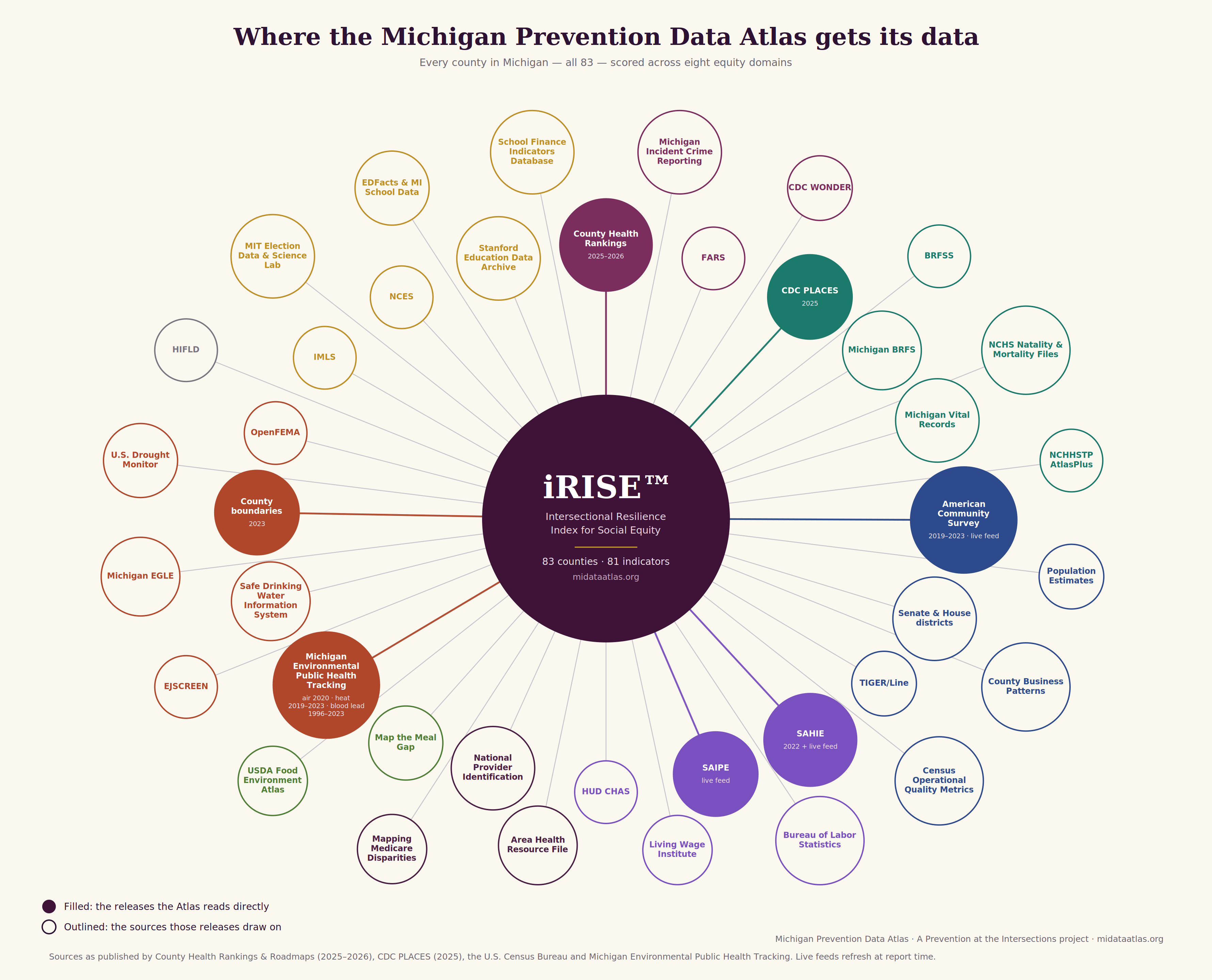
Each indicator in the Atlas is one of two kinds. An embedded value was obtained from the publisher’s release and stored in the Atlas for all 83 counties; its vintage is printed in every report and on the County Map (County Health Rankings and Roadmaps 2025–2026; CDC PLACES 2025 release; U.S. Census Bureau SAHIE 2022; Michigan Environmental Public Health Tracking air (2020), extreme heat (2019–2023) and adult blood-lead (1996–2023) exports.). A live value is retrieved in your browser from the publishing agency’s open API at the moment a report is generated and is marked LIVE. If a feed does not respond within twelve seconds, the embedded value stands and the report says which feeds did and did not respond.
Every indicator is ranked among the 83 counties, taking direction into account, so rank 1 is always the heaviest burden. Ranks fall into five bands: heaviest (top 20%), heavy, moderate, lighter, lightest.
Indicator ranks aggregate into clusters, clusters into eight equity domains scored 0–100 where higher is stronger, and domains into the composite iRISE™ index. Michigan’s composite is 50.3. Four indicators are embedded for reference but excluded from scoring because the publisher suppresses them for many counties.
Every report compares the county with one other county rather than a statewide median: by default the nearest county by road distance, or any county you choose. The gap on each domain is shown to scale, and the widest gap is the report’s lead finding. Michigan values are shown alongside for reference.
When a publisher withholds a value because the count is too small, the Atlas shows it as suppressed. It is never shown as zero, and it is never estimated.
It will not invent testimony, budgets, partners or within-county subgroup rates. Every such field in a report is marked with who must act: the Action required — Organization, an Action required — Individual, or the Action required — Community.
Every source the Atlas draws on, generated from the indicator registry embedded in this file so the list cannot drift from the data.
Terms used across the Report Builder, Solution Forge and County Map, including the indicator families added in this release.

Dr. Crystallee Crain is the founder of iRISE™ Data and the creator of the iRISE™ algorithm — the Intersectional Resilience Index for Social Equity — a measurement framework built on the premise that communities should have access to the data used to describe their reality. She also built the Michigan Prevention Data Atlas, the free, open-access platform that serves as the proof of concept for the national iRISE site, giving residents, advocates, and policymakers a shared way to see how resilience and risk are distributed across their communities.
Through her research and consulting practice, Prevention at the Intersections, founded in 2010, she has spent more than fifteen years working at the intersection of violence prevention, public health, participatory research, and community power building. Her work is grounded in community-based participatory research principles, equity, and deep systems change. This has included serving as Co-Principal Investigator on the Washington State LGBTQ+ Survey in partnership with Washington State University and the Washington State LGBTQ Commission.
Dr. Crain has held appointed public service roles on both coasts, including the Portland Human Rights Commission and the Alameda County Juvenile Justice and Delinquency Prevention Commission, where she brought a prevention lens to questions of equity, youth justice, and civil rights. She was elected Board Chair of the Seeding Justice Foundation, a role she held from 2022 to 2025, and she serves on the boards of the Michigan Nonprofit Association, Child Care Back Office, Grit Glam and Guts, and Detroit Heals Detroit.
An educator with more than eighteen years of university teaching experience, Dr. Crain has held academic appointments at Simmons University, California State University, Prescott College and Portland State University in social work, political science, sociology, and social justice studies departments. She also co-founded the Violence Prevention Certificate Program at College of Alameda, the first of its kind 16 years ago. She holds a Ph.D. in Transformative Studies from the California Institute of Integral Studies, Masters of Arts in Social Sciences from Eastern Michigan University, and a Bachelors of Science in Political Science from Northern Michigan University.
She is an award winning author, poet, visual artist, and now publisher. Her Cultural Humility in Practice Workbook received the 2024 International Impact Book Award. Her other titles include her first memoir Superfluous Pains and the four-book Defying Laws of Nature parable series, released through her imprint, Legacy Lane Publishing, and accompanied by a full grades 9–12 ELA-aligned curriculum.
She hosts the W3 Award-winning podcast Us with Dr. Crystallee Crain, leads the creative platform Her Creative Justice that curated the Inaugural Six Corners One Voice spoken word series focused on uplifting black female poets voices in her hometown of Flint, MI.
Author page on Amazon ↗ · Professional website ↗ · Prevention at the Intersections ↗ · Her Creative Justice ↗
Book a consultation with Dr. Crain
Contact: irisedata@gmail.com
The Michigan Prevention Data Atlas is free and open access for all 83 counties, with no paywall, no login and no data resold. Donations cover the research, the live federal feed maintenance and the hosting that keep it that way.
Donations are processed securely by Zeffy, which passes one hundred percent of each gift through to iRISE™ Data.
The Atlas is built with and for the communities it describes. Tell us what is working, what is missing, what reads wrong for your county, or what you would like to see measured next.
The form is short, anonymous unless you choose to leave contact details, and reviewed directly by the research team.